Study of 1987 Whittier Earthquake Reveals Previously Undetected Fault
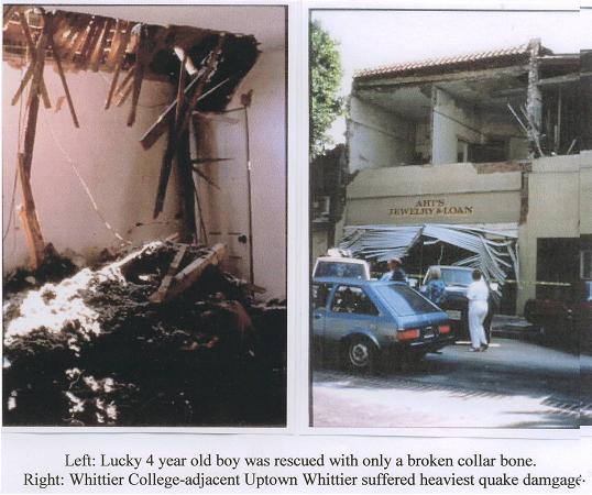
Analysis of the 1987 Whittier Earthquake (they occur periodically) led to the discovery of a previously undetected blind thrust fault and caused a paradigm shift in Los Angeles basin tectonics studies. The M 5.9 1987 Whittier earthquake took 8 lives, and caused property damage in the hundreds of millions of dollars. The most severe damage was in Uptown Whittier.
More than 10,000 residential and commercial structures were damaged by the October 1st earthquake. Structural damage found in the 5 and 605 freeways interchange required major repair. A student was killed in a parking structure collapse, and one of the landslides caused by the quake killed a Southern California Edison worker. The rupture cracked streets. In the 12700 block of Greenleaf Ave., the previously flat street was suddenly half a foot higher, or lower, depending on which side of the rupture one stood on, once one could stand again.
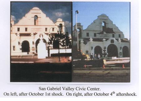
But it wasn’t over... On October 4th, a M 5.3 aftershock struck, further terrorizing the thousands of Whittier residents still sleeping outside, causing further injuries and damage.
The northern Los Angeles basin is forcing its way into the relatively stationary southern L. A. basin at about 5 mm annually. This process stores energy – until the complex and ever changing tectonic system’s holding strength is broken, triggering earthquakes. The fault discovered after the 1987 Whittier earthquake could release up to half that stored energy locally in a single seismic event.
And now the Big One
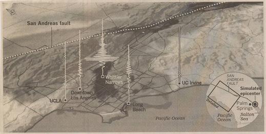
A recent study by the Southern California Earthquake Center, a consortium of 15 prestigious core institutions headquartered at USC, suggests much worse to come for the Whittier Narrows. The San Andreas fault, not the beach tens of miles to the south or the west, demarcates the ever clashing Pacific and continental tectonic plates. One SCEC program's objective is to pinpoint the degree of shaking that would take place in areas as precise as a block by following earthquake waves from the San Andreas fault through the different basin soils.
Because Whittier Narrows is composed of the San Gabriel River running south to Long Beach and weak sediments, all the communities in the Narrows are at special risk. As Prof. James Dolan at USC’s Earth Sciences Dept. explains, “The fault will pump energy directly into the basin and cause it to shake like a bowl of Jello.”
SCEC researchers have learned that the waves from earthquakes along the San Andreas fault are effectively funneled into the basin’s valleys much like flood water. Channeled through soft valley soils, the waves become slower and higher, even more devastating. The worst shaking would stretch from the 60 and 605 freeways interchange south through the Whittier Narrows until reaching the 91 freeway near Long Beach.
Clearly, Whittier College and surrounding communities present a uniquely
high earthquake risk in comparison with practically every other four-year
college site in the Los Angeles basin, especially when the Big One hits…
Recommended link:
The Southern California Earthquake Center
UpdateOn March 16, 2010, the 4.4 magnitude Pico Rivera earthquake, the epicenter of which was only a few miles from the deadly 1987 Whittier Narrows earthquake epicenter, shook nerves as well as the earth and structures.
Cal Tech seismologist Egill Hauksson said that the Pico Rivera quake was due to stress building up on that same fault, and should be thought of as "creaking underground before the big earthquake happens."
The Big One? It's only a matter of time...